- About Us
- Board of Directors
- Sections
- Guiding Documents
- Join APA and Its Divisions
- Contact Us
- Washington Planning Awards Information
- Events & Training
- Professional Development
- Sponsorship
- Get Involved
- Resources
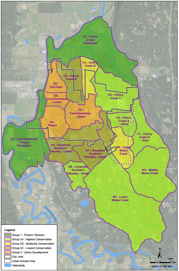
Watershed Planning to Support a Comprehensive Plan Update in the City of DuvallNote: The following article is the last of a three part series. Select the following links to access Part I and Part II. With grant support from the Lead Organization for Watershed Protection and Restoration under the U.S. Environmental Protection Agency’s National Estuary Program, the City of Duvall has been conducting a voluntary watershed planning process in support of the upcoming Comprehensive Plan update which is mandated by the Washington State Growth Management Act. The watershed planning process is a voluntary activity which provides the vision and technical background for the community to consider adopting improved development standards, policies, and programs. These programs will invest city resources into key areas to protect and restore watershed processes and habitats, while accommodating future population and employment growth. Additionally, the plan will serve as the basis for future grant funding of related programs. The city is developing a Watershed Plan that compares existing watershed characteristics within and immediately adjacent to its jurisdiction. Duvall is located on slopes above the Snoqualmie River and Cherry Creek, both important local and regional natural resources. The analysis integrates geospatial data from the Puget Sound Watershed Characterization indices of water flow and sediment processes with other landscape metrics such as impervious surface, potential salmon habitat, forest cover, and wetlands. The results provide the basis for a grouping of different sub-basins across the Duvall watershed into categories associated with broad management strategies. For example, sub-basins that are highly important to watershed processes are considered a priority for restoration programs and grouped into the Protect/Restore management group. Conversely, those sub-basins which are less important to watershed processes and highly impaired could be the focus of increased development, which the City is required to accommodate under the Growth Management Act, and grouped into the Urban Development management group.
Management strategies for each group were created alongside a toolkit of goals, policies, regulatory actions, and voluntary programs which all help address the City’s watershed needs. The Plan proposes policies and actions, both at the management group and city-wide scale such as: 1. Establishing and protecting habitat corridors 2. Improving tree canopy protections 3. Improving stream and wetland buffer protections 4. Instituting Low Impact Development best management practices for stormwater 5. Increasing development intensity in areas less important to watershed processes and highly impaired 6. Waiving stormwater flow control requirements in sub-basins prioritized for development where adjacent to the Snoqualmie River. These strategies are captured in 2-page portfolio sheets for each sub-basin that identify current conditions and management objectives. These portfolio sheets will be shared with property owners and developers at the permit counter as an educational tool and an approach to positively influence project design. Throughout the planning process, Duvall’s assessment and management toolkit was evaluated and refined by a technical advisory group comprised of state and county experts, tribal representatives, and local stakeholder groups. Additionally it was presented at City Planning Commission and City Council meetings and other public venues to solicit feedback and achieve stakeholder support. The Plan is on track for completion by the end of June 2015 and will be considered for adoption by City Council soon thereafter. For additional information on the Watershed Plan, contact Duvall Planning Director Lara Thomas, at: [email protected]. Visit the following link to read the Draft Plan. For more information on the Puget Sound Watershed Characterization contact Colin Hume ([email protected]) or go to the following link: And visit our web map application: https://fortress.wa.gov/ecy/coastalatlas/wc/landingpage.html
|
Upcoming Events
Wed Sep 23, 2026MRSC Webinar - Implementing and Monitoring Local Climate Plans Webinar Category: APA WA Events |
View Full Calendar
The Washington Planner
APA Washington's Monthly NewsletterRead the latest issue>>
Submit an article>>
Sponsors
