- About Us
- Board of Directors
- Sections
- Guiding Documents
- Join APA and Its Divisions
- Contact Us
- Washington Planning Awards Information
- Events & Training
- Professional Development
- Sponsorship
- Get Involved
- Resources
A Watershed Approach to Wetland MitigationBy Colin Hume Note: The following article is Part II of a three part series. Select the following LINK to access part I, “Planning by Watersheds to Protect Puget Sound”. The Hood Canal Coordinating Council (HCCC) is a nonprofit organization which acts as the Lead Entity for salmon recovery in the Hood Canal. The HCCC has been developing an In-Lieu-Fee (ILF) Program to provide strategic compensatory mitigation opportunities for unavoidable impacts to wetlands, streams, and marine and shoreline habitats in the Hood Canal drainages of Kitsap, Jefferson, and Mason counties. An ILF Program can sell mitigation credits to permittees whose obligation to provide compensatory mitigation is then transferred to the ILF Program sponsor. The intent of the HCCC’s ILF Program is to coordinate across jurisdictions to target mitigation opportunities that both satisfy regulatory requirements for permittees and provide the most benefit to the Hood Canal ecosystem as a whole. To inform the identification of opportunities to receive mitigation credits and achieve ecological “lift” the HCCC used the Puget Sound Watershed Characterization (PSWC) indices to perform a landscape scale assessment. For wetland opportunities the indices were used to filter through and identify the watersheds which are the highest value for water flow processes and freshwater habitats. For shoreline opportunities the PSWC Marine Index and the Puget Sound Nearshore Ecosystem Restoration (PSNERP) assessment were integrated to identify those beaches which are high value for both nearshore species and shoreline processes.
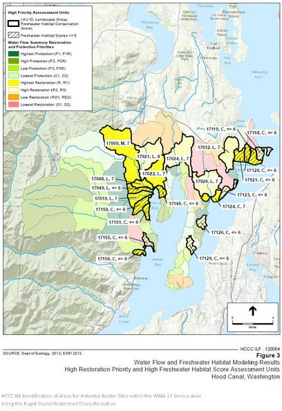
Above: Map illustrating priority watersheds for mitigation identified through the landscape assessment performed by HCCC using Puget Sound Watershed Characterization Indices. The landscape scale assessment was used in several different ways. First, it helped with the initial effort to screen the entire Hood Canal ecosystem for good mitigation opportunities by focusing further desktop and field investigations to a small subset of watersheds and beaches. Second, it offered many important criteria to evaluate and rank all of the sites that were identified, including good project opportunities which were found by local knowledge of the area, yet happened to be outside of the highest value watersheds and beaches. Additional consideration for site ranking was related to factors such as ownership, proximity to other restoration projects, feasibility of implementation, riparian cover and more criteria. Third, the assessment addressed the sustainability of proposed mitigation sites by evaluating the processes which may impact the success of restoration or protection based mitigation actions. Once good mitigation opportunity areas are identified, the final phase of establishing a mitigation site requires determining the functional credits which could be generated from restoration or protection actions. This step requires applying the Washington State Department of Ecology’s Wetland Credit/Debit tool for freshwater wetlands, or an interim tool developed for the nearshore areas, followed by a final review by the Interagency Review Team (IRT). This IRT is comprised of those agencies responsible for regulating development of wetlands, and it reviews and approves sites as available for mitigation actions. This process allows the ILF Program to match up and sell equivalent credits to a permittee to mitigate the loss of functions from development activities. See the HCCC ILF Story Map and case study for more detail on how the PSWC indices were applied: https://fortress.wa.gov/ecy/coastalatlas/wc/StoryMap.html?id=hood For more information on the PSWC contact Colin Hume at the Washington State Department of Ecology ([email protected] ) or go to the following link: http://www.ecy.wa.gov/puget_sound/characterization/index.html And visit our web map application https://fortress.wa.gov/ecy/coastalatlas/wc/landingpage.html Note: This article is Part II of a three part series. The upcoming article in May will illustrate an additional application of Puget Sound Watershed Characterization indices in a planning process lead by the City of Duvall.
|
Upcoming Events
Wed Sep 23, 2026MRSC Webinar - Implementing and Monitoring Local Climate Plans Webinar Category: APA WA Events |
View Full Calendar
The Washington Planner
APA Washington's Monthly NewsletterRead the latest issue>>
Submit an article>>
Sponsors
